
Stage 2: Hills and Plains
Amazing culture at every turn as the route hits the mountains
Stage 2 Actual Route

On this, and all other route maps, the blue lines represent travel by ship, red by airplane (Booo!), and green by bicycle.
Laos: A Great Addition
Up next was a last-minute addition to the route, an amazing visit to the country of Laos. I began to feel a desire to ride there while in Thailand, and made the decision to go while in Cambodia. So, there was not much time to plan the visit, certainly not to the level that I had done for the rest of the route. But I did what I could, and set out, a little unsure of what would lie ahead. My route started in the extreme south of the country, which is sparsely populated and correspondingly light in terms of services, and ran north along the Mekong Valley following a consistently good road. Along the way was a small, but pretty Khmer ruins site, at Wat Phou, and a couple of small, but interesting towns, such as Savannaket. Further north, I turned into the highlands, which included a section over some of the worst roads of the tour. Had I know it would be so rough, I surely would not have gone that way, of course now that it's in the past, I'm glad I did.
Once I broke out of the tough section, the route passed through one of the most appealing areas so far, through forested mountains with many interesting people and places. In fact, the Lao people were great all throughout the country, and many still partake in traditional cultural practices, which I found fascinating. Along the way, I visited the unusual Plane of Jars, an odd site left by an unknown prehistoric culture, and then finished the route through the country at Luang Pra Bang, a splendidly attractive community and a top contender to be my favorite city of the whole tour. I took a nice long break there, which was a little longer than I'd hoped as I ate something that I shouldn't have and had to take a sick day. Because of that I didn't have time to ride back to Thailand through the capital, Vientiane, as I had planned, but had to take a boat transfer up the Mekong to a northern Thai border crossing. That was fun in it's own way, but was noisier and faster than I would have liked.
Posts now begin to expand starting: ~HERE~
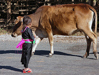
A little girl watches a cow
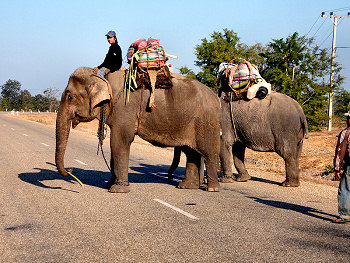
Heavy traffic on Highway 13
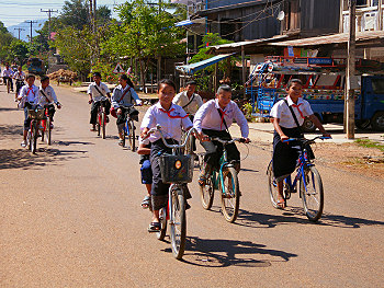
Students biking home from school
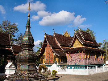
Wat Xieng Thong in the lovely town of Luang Pra Bang
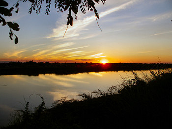
Sunset over the Mekong River
Myammar: Stunning, but Sadly Suffering
Myanmar was a country that at once approached the best and worst of Stage 2. It turned out to be a rather difficult place to tour, by my standards at least. One big reason for that was the almost universally bad roads. Most of the "good" roads were unpleasantly bumpy, and the bad ones were just disastrous. On top of that, the country has been suffering for years under the oppressive and, frankly, inept rule of a cadre of former military officers. From messing up the Internet, to closing off large parts of the country to travelers without good reason, their policies only served to make things difficult for me. Worst of all is that after five decades, or so, of xenophobic governments of one sort or another, it is essentially impossible to travel into or out of the country overland. That meant two very annoying air transfers in and out of the country, both of which were complicated and unpleasant thanks to airline screw-ups. Of course, things are even worse for the people who live in the country.
On the bright side, Myanmar had some of the best and most impressive cultural sights I have ever seen. Additionally, the people there were, once again, fantastic and possessed a culture which was surprisingly distinct from their neighbors. My initial plan was to do a loop from the capital, Yangon, north to the city of Mandalay and back. That would have allowed me to see all of the main sights in the "allowed" tourist area, and apply for my visa for India (a frustratingly slow process) on the first stop in Yangon, and then pick it up later. Things started out fairly well, but then became increasingly difficult thanks to the aforementioned government restrictions and bad roads, the latter of which became increasingly poor as I entered the mountains. Nevertheless, I saw Inle Lake and the unique and friendly Intha people who live around it, the impressive cave temple at Pindaya, Mandalay and its former Royal Palace, and stumbled upon a fascinating dedication ceremony of a freshly-renovated pagoda in the countryside. However, it was the ancient city of Bagan which completely shocked me with its inspiring collection of temples and pagodas, many of which are still important religious places for the local population.
Unfortunately, after all of the difficulties riding through Myanmar, I was well behind schedule by the time I reached Bagan, and I did not have time to ride back to Yangon, and so I had to start the air transfer from there, which was very annoying. On the bright side, that gave me another day to see the ruins. It was a slightly disturbing visit, because the political situation in the country shows no sign of improving any time soon. Once it does, the country would certainly become one of the world's top destinations, but more importantly, the lives of it's people can get back on track.
Myanmar could fill many posts like the one: ~HERE~
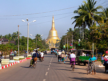
A city street and a golden Stupa in Bago
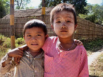
Kids from a mountain village
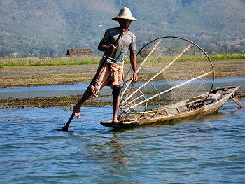
Rowing by foot on Inle Lake
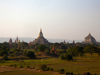
Evening at the splendid ancient city of Bagan
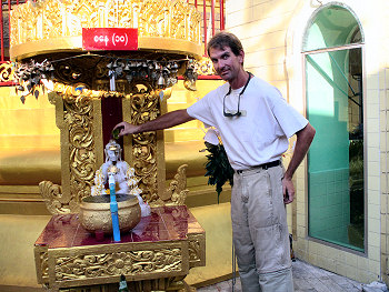
I "Water the Buddha" at Sule Pagoda in Yangon
Bangladesh: Controlled Chaos on the Plains
Bangladesh was next, though being a small country in terms of land area, I did not stay there for very long. Small in terms of land, Bangladesh is large in terms of people, being one of the most densely populated lands on Earth. That fact touched every aspect of my travels through the country. Since I was required to fly out of Myanmar, I arrived in the capital, Dhaka, a huge city, and is the top contender for the craziest city of the tour. I stayed for a little longer than I wanted, because a package of supplies I had sent from home was delivered a little late. Traffic there, and throughout the rest of the country, was probably louder, dirtier, and more dangerously uncontrolled than anywhere else in the world.
Once out of the big city, the environs changed from urban to mainly rural and agrarian. However, the population remained heavy, even in the countryside. Because of that, I essentially gave up camping as my main accommodation as there were just too many people around. As it turned out I would camp only a few more times during the rest of the Stage in Asia. It was also quite difficult to find a moment’s privacy to rest along the way. However, there was always someone doing something interesting every few meters along the way, which made up a little for the crowds and traffic. There were few cultural or natural sites easily accessible along the route, but one was the ruins of an ancient Buddhist vihara in Paharpur. Despite the somewhat stressful nature of traveling there I felt a bit satisfied that I did so successfully, once I had made it through, at least.
A fairly short post for a small country: ~HERE~
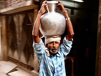
A man carries water through Chawk Bazaar in Dhaka
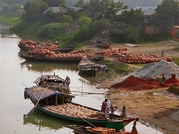
Clay pots and other goods being sent up river
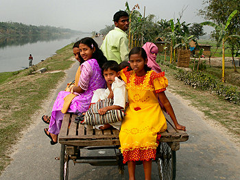
Colorful dresses on travelling ladies
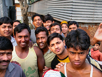
Men from a textile-making village
Bhutan: Buccolic and Beautiful
After several tough weeks, I reached my most anticipated destination, the Himalayan Kingdom of Bhutan. That small, but beautiful, country has its own issues for travelers, but they are of a completely different nature. There are tight regulations of tourism there, in order to prevent uncontrolled development, and consequently tourists need to be accompanied by a guide and the costs for travel are high compared to the rest of Asia. Having a guide and support was not my normal mode of travel, and I never really got completely used to it. Additionally, of course, the mighty Himalayas pose their own challenges and, because of that it, was not always so bad to have support along.
I wanted to see as much of the country as possible, and that required special permission, which was fortunately obtained by the tour company. The route entered the country at its southwestern border crossing with India, climbed quickly up to altitudes above 2,300 meters, and then took me to the towns of Paro and the capital, Thimphu, the largest two towns in the country. From there we turned east and crossed six or seven high passes, up to 3,780 meters at Thrumshing La and a total of almost 15,000 meters of climbing, along the way visiting the small, but lovely, towns of Punhaka, Trongsa, Jakar, Mongar, Lhuntse, and Trashigang. The final day way a long, strenuous turn to the south back towards the Indian border at the town of Samdrup Jongnkhar. In spite of the tough terrain, the ride was amazing, and I really fell for the great people, distinct and colorful culture, and spectacular scenery of Bhutan.
The sights of Bhutan are described in a post: ~HERE~
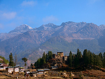
Into the Himalyas at last, at Paro
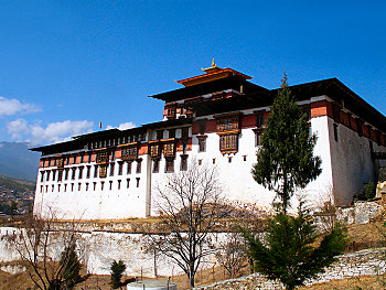
Paro Dzong
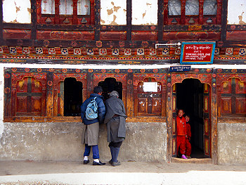
A small town shopfront
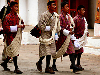
Men in Punhaka Dzong
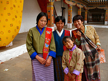
Women in Punhaka Dzong
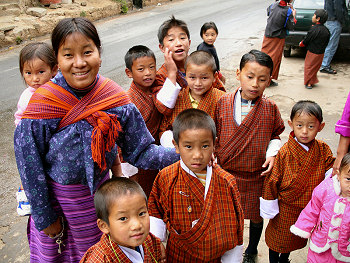
The first day of school in Wangdue Phodrang
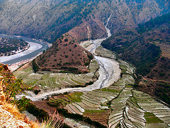
Terraces and a river near Trashigang
Previous | Next
Main Index | Pre-Tour Index
Post-Tour Index | Articles Index
Slideshows
Stage 2 Log
(continued)
For a description of terms and symbols look: ~HERE~
December 27, 02005
Stung Treng to Kheo, Laos
Distance: 141 km
Terrain: Light rolling

Max. Elevation: 430 m
Roads: Hwy 7 (60 km dirt/gravel), Hwy 13 (Laos)
Max. Temp: 28 °C
Weather: Partly to mostly cloudy
Accommodation:

Comment: Slow border crossing, nice road with little traffic once in Laos
December 28
Kheo to Pakxe
Distance: 130 km
Terrain: Light to moderate rolling

Max. Elevation: 460 m
Roads: Hwy 13
Max. Temp: 31 °C
Weather: Mostly sunny, increasing clouds in
afternoon
Accommodation:

Comment: Visited Wat Phou and Wat Oumuang; did not get as far as hoped due to visit detour
December 29
Pakxe to Ban Xe Bang Nouan
Distance: 145 km
Terrain: Light to moderate rolling

Max. Elevation: 460 m
Roads: Hwy 13
Max. Temp: 32 °C
Weather: Sunny; moderate to strong headwinds
Accommodation:

Comment: Tiring day due to wind, did not get as far as hoped
December 30
Ban Xe Bang Nouan to Savannakhet
Distance: 112 km
Terrain: Light to moderate rolling

Max. Elevation: 360 m
Roads: Hwy 13, Savannakhet Rd
Max. Temp: 34 °C
Weather: Sunny; light to moderate crosswinds
Accommodation:

Comment: Long half day to short break in Savannakhet
December 31
Savannakhet to 20 km N. of Thakhek
Distance: 156 km
Terrain: Light to moderate rolling

Max. Elevation: 400 m
Roads: Savannakhet Rd, Hwy 13
Max. Temp: 31 °C
Weather: Sunny; light to moderate cross/headwinds
Accommodation:

Comment: An uneventful day
January 1, 02006
20 km N. of Thakhek to Ban Thana
Distance: 162 km
Terrain: Light to moderate rolling

Max. Elevation: 360 m
Roads: Hwy 13
Max. Temp: 32 °C
Weather: Sunny
Accommodation:

Comment: A pleasant day with no wind
January 2
Ban Thana to 30 km N. of Ban Thabok
Distance: 150 km
Terrain: Light to moderate rolling, then gradual ascent

Max. Elevation: 670 m
Roads: Hwy 13, Pakxan-Borikhan Rd, Hwy 13, Ang Nam Leuk Dam Rd (dirt)
Max. Temp: 32 °C
Weather: Sunny, occasional light winds, various direction
Accommodation:

Comment: Wasted morning by trying to go north from Pakxan, only to be turned back by police after 24 km
January 3
30 km N. of Ban Thabok to Unknown Location
Distance: 114 km
Terrain: Hilly, 500-m descent; moderate to heavy rolling; mountainous, two steep 500-m climbs

Max. Elevation: 905 m
Roads: Ang Nam Leuk Dam Rd (25 km dirt, then paved), Long Say-Thong Khoun Rd (80 km paved with last ~20 km under construction, then dirt)
Max. Temp: 34 °C
Weather: Sunny
Accommodation:

Comment: Very slow day due to rough terrain and dusty roads
January 4
Unknown Location to Ban Tha Vieng
Distance: 60 km
Terrain: Hilly, then mountainous, 400-m climb, steep, rolling 600-m descent

Max. Elevation: 1,260 m
Roads: Unknown Road (mix of paved sections and very rocky dirt)
Max. Temp: 30 °C
Weather: Sunny
Accommodation:

Comment: Painfully slow day
January 5
Ban Tha Vieng to 25 km W. of Phonvason
Distance: 133 km
Terrain: Mountainous, 820-m climb, then moderate to heavy rolling

Max. Elevation: 1,165 m
Roads: Tha Vieng-Xieng Koang Rd. (good dirt/gravel), Hwy 1D, Hwy 7
Max. Temp: 26 °C
Weather: Sunny, late evening tailwind
Accommodation:

Comment: Long climb early, broke through into good conditions at Xieng Koang; visited Plane of Jars
January 6
25 km W. of Phonvason to 35 km N. of Phoe Khone
Distance: 142 km
Terrain: Moderate rolling, then mountainous to hilly, two 500-m descents, 600-m climb, 400-m climb, several 100-200-m climbs

Max. Elevation: 1,395 m
Roads: Hwy 7, Hwy 13
Max. Temp: 23 °C
Weather: Sunny
Accommodation:

Comment: A lot of hills, but very scenic and pleasant day; map misrepresented distance to Luang Pra Bang, so could not arrive there as hoped
January 7
35 km N. of Phoe Khone to Luang Pra Bang
Distance: 95 km
Terrain: Mountainous, 1050-m descent, 650-m climb/descent

Max. Elevation: 1,450 m
Roads: Hwy 13
Max. Temp: 25 °C
Weather: Fog/clouds through midday, then mostly sunny
Accommodation:

Comment: A hilly half day to a much-needed long rest break in Luang Pra Bang
January 8
Luang Pra Bang
Accommodation:

Comment: A nice rest/sightseeing day in Luang Pra Bang
January 9
Luang Pra Bang
Accommodation:

Comment: Rest/sightseeing day in Luang Pra Bang
January 10
Luang Pra Bang
Accommodation:

Comment: Recovery day in Luang Pra Bang, due to food-caused illness
January 11
Luang Pra Bang to Chiang Khong, Thailand
Distance: 17 km
Accommodation:

Comment: Transfer to Thailand on Mekong River boat, arrived just after immigration closed
January 12
Chiang Khong to Pong
Distance: 154 km
Terrain: Flat to moderate rolling

Max. Elevation: 500 m
Roads: Hwy 1020, Hwy 1021, Hwy 1148, Hwy 1179, Hwy 1092
Max. Temp: 33 °C
Weather: Thick morning fog, then sunny
Accommodation:

Comment: Late start for border formalities, and a poor appetite, but easy riding conditions
January 13
Pong to Phrae
Distance: 155 km
Terrain: Light to heavy rolling with one small hill

Max. Elevation: <300 m
Roads: Hwy 1091, Hwy 1120, Hwy 1154, Hwy 103, Hwy 101
Max. Temp: 32 °C
Weather: Thick morning fog, then sunny
Accommodation:

Comment: Poor appetite, low energy, tiring day
January 14
Phrae
Accommodation:

Comment: Recovery day in Phrae
January 15
Phrae to Sukhothai
Distance: 173 km
Terrain: Light to heavy rolling, then flat

Max. Elevation: <300 m
Roads: Hwy 101
Max. Temp: 33 °C
Weather: Sunny
Accommodation:

Comment: Felt a little better, still a long day
January 16
Sukhothai to Kum Noeng
Distance: 117 km
Terrain: Flat to moderate rolling

Max. Elevation: <300 m
Roads: Hwy 12, Hwy 1113, Hwy 1048
Max. Temp: 33 °C
Weather: Sunny
Accommodation:

Comment: Short day for a little sightseeing at ruins of Old Sukhothai
January 17
Kum Noeng to Chiang Mai Airport
Distance: 218 km
Terrain: Light to moderate rolling, 350-m climb and one small climb

Max. Elevation: 380 m
Roads: Hwy 1048, Hwy 106
Max. Temp: 32 °C
Weather: Sunny
Accommodation:

Comment: Very long day to an unwelcome air transfer to Yangon via Bangkok; made flight with minutes to spare
January 18
Yangon, Myanmar
Accommodation:

Comment: Arrival in Yangon and day for errands, applied for India visa
January 19
Yangon
Accommodation:

Comment: Rest day in Yangon
January 20
Yangon to Diak U
Distance: 144 km
Terrain: Flat to light rolling

Max. Elevation: <300 m
Roads: Hwy 1
Max. Temp: 31 °C
Weather: Sunny
Accommodation:

Comment: A reasonable first day in new country; some bumpy roads
January 21
Diak U to Taungoo
Distance: 154 km
Terrain: Flat to light rolling

Max. Elevation: <300 m
Roads: Hwy 1
Max. Temp: 31 °C
Weather: Morning fog, then sunny
Accommodation:

Comment: More bumpy road surface made a rather tedious day
January 22
Taungoo to Pyinmana
Distance: 135 km
Terrain: Flat to light rolling

Max. Elevation: <300 m
Roads: Hwy 1
Max. Temp: 30 °C
Weather: Morning fog, then sunny; a few light headwinds in afternoon
Accommodation:

Comment: Couldn't take direct route to Inle Lake, or stay in Pyinmana due to stupid government restrictions; bus transfer to Yamethin
January 23
Yamethin to Aungbang
Distance: 135 km
Terrain: Flat to light rolling, then 1,360-m climb

Max. Elevation: 1,450 m
Roads: Hwy 1, Pyawbwe cut-off, Hwy 4 (poor condition)
Max. Temp: 27 °C
Weather: Sunny
Accommodation:

Comment: Very slow day due to bumpy road and big climb; did not get as far as hoped
January 24
Nyuang Shwe
Distance: 45 km

Accommodation:

Comment: Short ride to rest day at Nyuang Shwe; visited Inle Lake floating villages
January 25
Nyuang Shwe to Pindaya
Distance: 94 km
Terrain: Light to heavy rolling, 500-m climb

Max. Elevation: 1,460 m
Roads: Hwy 4, Hwy 41
Max. Temp: 26 °C
Weather: Sunny
Accommodation:

Comment: Lost voice overnight; shortened route to a long half day; visited Pindaya Cave Pagoda
January 26
Pindaya to Myu Gyi
Distance: 130 km
Terrain: Moderate to heavy rolling with 450 meters of elevation gain, 1,290-m descent

Max. Elevation: 1,630 m
Roads: Hwy 41, Hwy 411
Max. Temp: 29 °C
Weather: Sunny
Accommodation:

Comment: Felt a little better, but due to horribly bumpy road, especially on big descent, could not get close to Mandalay as hoped
January 27
Myu Gyi to Mandalay
Distance: 82 km
Terrain: Light rolling to flat

Max. Elevation: 344 m
Roads: Hwy 411, Hwy 3
Max. Temp: 29 °C
Weather: Sunny
Accommodation:

Comment: Half day to a rest break at Mandalay
January 28
Mandalay
Accommodation:

Comment: Rest day in Mandalay
January 29
Mandalay to Myingyan
Distance: 121 km
Terrain: Light to moderate rolling

Max. Elevation: 425 m
Roads: Mandalay-Inwa Rd., Inwa-Myotha Rd. (several long dirt/gravel sections), Hwy 18
Max. Temp: 27 °C
Weather: Sunny
Accommodation:

Comment: Short day due to bumpy roads and a little sightseeing; watched pagoda dedication ceremony in Amarapura
January 30
Myingyan to Bagan
Distance: 100 km
Terrain: light rolling

Max. Elevation: 320 m
Roads: Myingyan-Bagan Rd. (sandy dirt)
Max. Temp: 28 °C
Weather: Sunny
Accommodation:

Comment: Half day for sightseeing in Bagan
January 31
Bagan to Chauk
Distance: 108 km
Terrain: Gradual 350-m climb/descent, then moderate rolling

Max. Elevation: 660 m
Roads: Nyuang U-Kyuak Paduang Rd., Hwy 2, Chauk-Bagan Rd. (error)
Max. Temp: 32 °C
Weather: Sunny, a few light crosswinds in afternoon
Accommodation:

Comment: Short day; late start due to sightseeing in Bagan; made wrong turn that lead to Chauk, was not allowed to spend night there
February 1
Bagan
Distance: 55 km
Accommodation:

Comment: Short ride to sightseeing day in Bagan
February 2
Yangon
Accommodation:

Comment: Air transfer to Yangon
February 3
Yangon
Accommodation:

Comment: Rest/chores day in Yangon
February 4
Yangon
Accommodation:

Comment: Rest/sightseeing day in Yangon; visited Shwe Dagon Pagoda
February 5
Yangon
Accommodation:

Comment: Intended air transfer, but stuck in Yangon due to airline screw-up
February 6
Yangon to Dhaka, Bangladesh
Accommodation:

Comment: Long, tiring air transfer to Dhaka
February 7
Dhaka
Accommodation:

Comment: Rest day in Dhaka
February 8
Dhaka
Accommodation:

Comment: Sightseeing day in Dhaka
February 9
Dhaka
Accommodation:

Comment: Waiting in Dhaka for a package of supplies sent from the U.S.
February 10
Dhaka to Dulai
Distance: 121 km
Terrain: Flat

Max. Elevation: <300 m
Roads: Aricha Hwy, Brahmaputra Ferry, Pabna Rd.
Max. Temp: 28 °C
Weather: Hazy sun
Accommodation:

Comment: Very congested leaving Dhaka, river crossing took longer than anticipated; did not get quite as far as planned
February 11
Dulai to 15 km S. of Bogra
Distance: 153 km
Terrain: Flat

Max. Elevation: <300 m
Roads: Pabna Rd., Pabna-Natore Rd., Natore-Bogra Rd.
Max. Temp: 28 °C
Weather: Hazy sun
Accommodation:

Comment: A relatively easy day, but felt a little tired
February 12
15 km S. of Bogra to Guranjagan
Distance: 149 km
Terrain: Flat

Max. Elevation: <300 m
Roads: Rangpur Hwy, Jaipurhat Rd., Local Rds., Jaipurhat Rd.,
Rangpur Hwy.
Max. Temp: 28 °C
Weather: Hazy sun
Accommodation:

Comment: Made a long detour via Jaipurhat to visit ruins of Paharpur Monastery
February 13
Guranjagan to Patgram
Distance: 166 km
Terrain: Flat

Max. Elevation: <300 m
Roads: Rangpur Hwy, Teesta Canal Rd., Patgram Rd.
Max. Temp: 29 °C
Weather: Haze
Accommodation:

Comment: Improved riding conditions in afternoon, but ride felt longer than actually was
February 14
Patgram to Phuentsholing, Bhutan
Distance: 135 km
Terrain: Flat, with gradual elevation gain

Max. Elevation: 430 m
Roads: Burimari Rd., Hwy 12-A (India), Hwy 31, Jaigoan Rd
Max. Temp: 28 °C
Weather: Haze
Accommodation:

Comment: Very slow crossing of Bangla-India border, rode all the way across India to arrive in Bhutan
February 15
Phuentsholing to
Chhukha
Distance: 83 km
Terrain: Mountainous, 1,880-m climb, 520-m descent

Max. Elevation: 2,280 m
Roads: Bhutan Hwy
Max. Temp: 23 °C
Weather: Cloudy/foggy
Accommodation:

Comment: Long half day after immigration formalities, etc.; Began first ascent into the Himalayas
February 16
Chhukha to Paro
Distance: 83 km
Terrain: Mountainous, 600-m climb, 430-m climb, 500-m descent

Max. Elevation: 2,545 m
Roads: Bhutan Hwy,
Paro Rd.
Max. Temp: 19 °C
Weather: Sunny, afternoon clouds, occasional moderate tailwinds, light shower in evening
Accommodation:

Comment: A fairly slow pace to reach Paro, over Chupkha La, a beautiful morning
February 17
Paro to Thimphu
Distance: 54 km
Terrain: Light to heavy rolling

Max. Elevation: 2,430 m
Roads: Paro Rd., Bhutan Hwy, Thimpu Rd.
Max. Temp: 18 °C
Weather: Mostly sunny, increasing clouds and occasional gusty wids from various directions in afternoon
Accommodation:

Comment: Morning sightseeing in Paro, then a short half day to Thimphu
February 18
Thimphu
Accommodation:

Comment: Rest/sightseeing day in Thimphu
February 19
Thimphu to Wangdue Phodrang
Distance: 108 km
Terrain: Mountainous, 800-m climb, 1,900-m descent

Max. Elevation: 3,220 m
Roads: Thimpu Rd., Bhutan Hwy.
Max. Temp: 23 °C
Weather: Morning and afternoon clouds, otherwise s
Accommodation:

Comment: Turned east towards center of country; Big climb over Dorcha La; visited Phunakha Dzong
February 20
Wangdue Phodrang to Chendebji
Distance: 87 km
Terrain: Mountainous, 1,870-m climb, 940-m descent

Max. Elevation: 3,420 m
Roads: Bhutan Hwy.
Max. Temp: 16 °C
Weather: Cloudy
Accommodation:

Comment: A slow but interesting day, with one big climb (Pele La); very cold (3C) at summit; saw monkeys and yaks
February 21
Chendebji to Jakar
Distance: 109 km
Terrain: Mountainous, 500-m descent, 1,340-m climb, 900-m descent

Max. Elevation: 3,425 m
Roads: Bhutan Hwy.
Max. Temp: 21 °C
Weather: Mostly to partly cloudy
Accommodation:

Comment: Another day with a big climb (Yatong La); cold (5C) at summit
February 22
Jakar to Sengor
Distance: 104 km
Terrain: Mountainous, 1,000-m climb, 490-m descent , 850-m climb, 750-m descent

Max. Elevation: 3,780 m
Roads: Bhutan Hwy.
Max. Temp: 20 °C
Weather: Mostly sunny to mostly cloudy
Accommodation:

Comment: A pretty day, two big passes (Sha Thang La, Thrumshing La) nice on first, cold on second
February 23
Sengor to Mongar
Distance: 86 km
Terrain: Mountainous, 2,425-m descent, 1,030-m climb

Max. Elevation: 3,015 m
Roads: Bhutan Hwy.
Max. Temp: 24 °C
Weather: Mostly sunny through morning, then mostly cloudy
Accommodation:

Comment: A crazily hilly half day to a brief rest in Mongar; some very beautiful scenery
February 24
Mongar to Lhuntse - and return
Distance: 153 km
Terrain: Mountainous, 800-m descent, gradual 710-m climb, last 250-m steep; then reversed

Max. Elevation: 1,660 m
Roads: Bhutan Hwy., Lhuntse Rd.
Max. Temp: 27 °C
Weather: Morning and afternoon clouds, otherwise mostly sunny
Accommodation:

Comment: A spectacular ride through Kuru River Valley and Gorge; visited Lhuntse Dzong
February 25
Mongar to Trashigang
Distance: 92 km
Terrain: Mountainous, 750-m climb, 1,630-m descent, 250-m climbs

Max. Elevation: 2,590 m
Roads: Bhutan Hwy.
Max. Temp: 32 °C
Weather: Morning and afternoon clouds, otherwise mostly sunny
Accommodation:

Comment: A relatively easy half day to Trashigang, climbed over Kori La
February 26
Trashigang to Samdrup Jongkhar
Distance: 181 km
Terrain: Mountainous, 1,570-m climb, 650-m rolling descent, 520-m climb, 2270-m descent

Max. Elevation: 2,676 m
Roads: Bhutan Hwy.
Max. Temp: 21 °C
Weather: Cloudy/foggy
Accommodation:

Comment: A very long and tiring day to reach border; more climbing than expected, Yongphu La and smaller climbs
Continued on Next Page
Index | Next Page
Pre-Tour Stage 1 Stage 2 Stage 3 Stage 4 Stage 5 |